
|
|||||||||||||
2021 was a strange year due its long periods of quiet activity, however between these lulls the year was rich in dramatic transient events and photo opportunities. Of note was the aerial snowscapes from Benbradagh, the Glenshane Pass morning blizzard, the Slaughtneil funnel cloud, Armagh updraught base, the Summer heatwave sunsets and massive thunderstorms, the first decent aurora in years, the remarkable Atlas Rocket Stage De-burn, Ballymena shelf cloud and most memorable of all was the emotional roller coaster ride of the Toome area tornado - the first confirmed tornado I have ever captured since I began chasing. Why not experience these moments with me through these 16 image reports.
| First image report of 2021 covering three days of local Winter chasing during late January 2021 covering a beautiful cold spell which brought several days of snow and even the first convection of the season. The chase began with impressive cold air convection over the ocean at Downhill Beach with cells dropping hail and snow then moves inland to cover two memorable days on Benbradagh mountain near Dungiven. The mountain was covered in snow and looked its finest in bright sunshine surrounded by a deep blue Polar sky. I also captured the waxing gibbous Moon rising over the snow-covered summit. This is a combination of DSLR and drone imagery. One page report with 20 images and 2 video clips. - REPORT. | 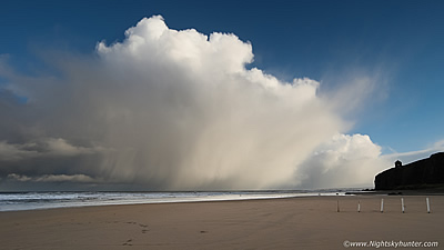 |
| During February 2021 a week long cold spell affected UK and Ireland in the form of an Ely flow from Siberia as a result of a large scale high pressure set-up. For N. Ireland this resulted in a very cold exceptionally dry week and with negative daytime temps in the wind chill it looked like ice formations were possible. On three different days I documented glaze ice and icicles on Lough Fea and Glenshane Pass, some of which were 6ft in length. The cold spell ended with a climatic blizzard which my Dad and I chased on Glenshane Pass which resulted in dramatic blowing snow scenes, a jack-knifed lorry and the best daytime blizzard action since 2010. One page report with 29 images and 2 video clips. - REPORT. | 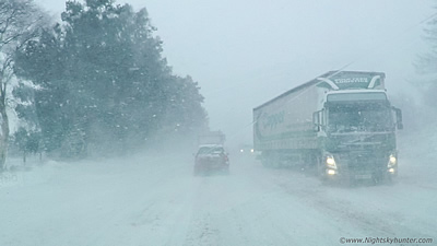 |
| Those who follow me on youtube will know that I have a fascination for filming ships on the north coast of N. Ireland. I seldom mention this passion on here as I like to keep the content on the site orientated towards Astronomy and Storm Chasing. However this vessel makes an exception and is more than worthy of inclusion. On Feb 15th 2021 the brand new 'Sir David Attenborough' Polar research vessel was due to visit Portrush for sea trials in preparation for months of exploration and scientific research in Antarctica. This report documents my attempts to track her down while battling inclement weather to capture her by drone. The early rise and long wait was worth it when all the elements came together for a great day. One page report with 11 images and 2 video clips. - REPORT. | 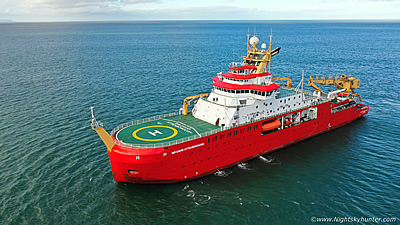 |
| Detailed report covering a range of night shoots in April 2021 - Astronomical telescopic observations, Zodiacal Light, Nova V1405 Cass and Asteroid 4 Vesta. First official meet up and night shoot of the year with mates shooting nightscapes and star trails at the Crucifixion scene and Lady of Wayside chapel in Broughderg as well as the Milky Way with mag +8 Nova over Beaghmore Stone Circles. This report also documents deep sky and comet observing with the 10" F/5 Reflector including the first convective skies and lowering of the Spring season. One page report with 19 images. - REPORT. | 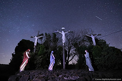 |
| Storm season has arrived and as we entered May the synoptic outlook took on a more unsettled and unstable pattern which produced over a week of convective potential. This report documents five chase days which resulted on the capture of a funnel cloud outbreak. On May 1st I captured 2 funnel clouds over Lough Foyle five minutes apart then May 12th I got treated to two more funnels over Carntogher outside Slaughtneil, the first funnel lasted for five minutes and was a dramatic sight has it hung in the sky like a dagger. These recent funnel sightings also broke several personal records by being the earliest and latest funnels I've ever seen. One page report with 21 images. - REPORT. | 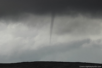 |
| This report covers two storm chases and a partial solar eclipse which I observed from the newly opened OM Dark Sky Park & Observatory with the staff and IAA when we successfully captured the eclipse through cloud during the 30% peak. The highlight of this report was an unexpected local chase when strong solar heating broke the cap resulting in rapid convection by late afternoon. I chased a growing cell from Maghera to a scenic vantage point near Knockloughrim and got rewarded with a beautiful single cell thunderstorm in full sunshine surrounded by blue skies rumbling away over the Co. Antrim countryside. One page report with 12 images and 1 video clip. - REPORT. | 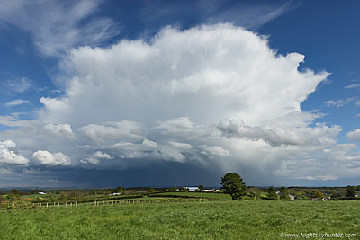 |
| After a complete storm drought during June we finally got our first chase day on July 4th 2021. The initial evaluation was not encouraging with concerns of grey skies and no shear however the atmosphere soon responded and took us by surprise. My Wife and I targeted the north coast where we watched convection and developing storms from Benone and Magilligan, we joined up with Nigel McFarland and Colleen Webb and ended up experiencing five thunderstorms. The highlight was standing within a beautiful wheat field near Myroe with dark storm clouds flashing and rumbling in front of us, at one stage three storms surrounded us. We witnessed in-cloud & c-g lightning including a terrific positive bolt. These storms damaged roads and struck a coffin factory in Strabane causing a huge fire. One page report with 15 images and 1 video clip. - REPORT. | 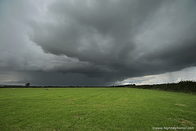 |
| July 12th would see the best instability of the current season with up to 1000j/kg under hot humid skies with the influence of high pressure. During the late afternoon Roisin and I went chasing in our target area of Co. Armagh and after a long wait the cap finally broke with explosive thunderstorm development. After a period of core punching and navigating narrow and twisting country roads we intercepted a thunderstorm at close range in the countryside west of Armagh. This storm had the best rain free updraught base I have ever seen on a N. Ireland storm with churning and twisting clouds under its inflow area, we captured the scene from a field with close range lightning and over 30 rumbles of thunder. One page report with 9 images and 1 video clip. - REPORT. | 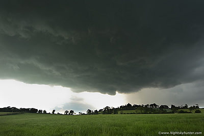 |
| July 12th turned out to be an action packed day, after chasing an intense thunderstorm in Co. Armagh the sky cleared that same night. Following a tip off from a fellow observer I drove out to Beaghmore and witnessed the best Noctilucent Cloud display of the season. The display was type 4 in brightness and exhibited beautiful structure in the form of large whirls, knots and waves glowing electric blue and gold during the darkest hour of the Summer night. I photographed and time lapsed the display over a lone fairy tree. One page report with 10 images and 1 video clip. - REPORT. | 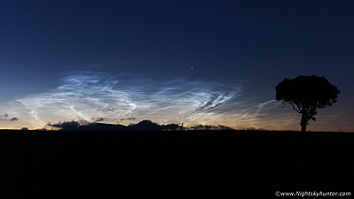 |
| A remarkable period of hot weather with a rare amber warning heat advisory from the Met Office for a risk to health and infrastructure. During the course of a week N. Ireland broke its all time temp record three times with a new historic temp of 31.3 degrees C. The heatwave brought beautiful sunsets, drought & on July 21st the most intense thunderstorms of the year. The cap broke releasing 1400j/kg of CAPE which generated Cbs 11km tall producing constant thunder for almost an hour each. A storm over Swatragh wind turbines formed a rare wet microburst, in total I intercepted six intense storms on this memorable day. One page report with 22 images and video 4 clips. - REPORT. | 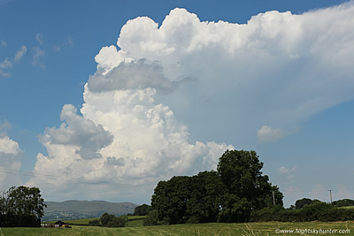 |
| August 4th 2021 brought a risk of flooding and slow moving thunderstorms. After a 03.30 rise and early morning photo shoot along the Co. Antrim coast I headed inland during the afternoon and teamed up with Nigel McFarland and Colleen Webb chasing a front which was breaking up unto multicellular clusters. We intercepted our first storm of the day near Kilrea which produced prolific thunder however the real prize came in the evening when a second storm approached Clady then Ballymena sporting an impressive Shelf Cloud spanning across 180 degrees of sky, we chased ahead of it to keep the structure in view and got rewarded with our the best Arcus Cloud in years. One page report with 15 images and 1 video clip. - REPORT. | 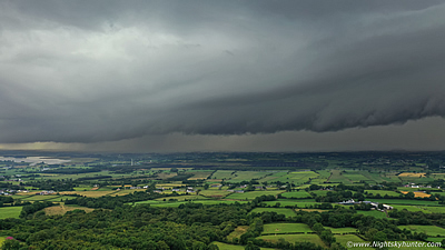 |
| August 9th 2021 was the day my dream came true. After many hours spent watching convection and chasing my tail for miles across the country I came home about to give up when I spotted huge updraughts erupting up into the evening sky to the NE. I gave chase, when I crested a hill I was astonished to witness the best funnel cloud of my life in the form of a huge solid white stove pipe seemingly going all the way to the ground, this would turn out to be over Toome and touched down as a EF0 tornado, this would be my first ever tornado in over 14 years of storm chasing. The cells which spawned it then put on a dramatic sight over Lough Neagh where I bagged another smaller funnel cloud, this was an historic day. One page report with 20 images and 1 video clip. - REPORT. | 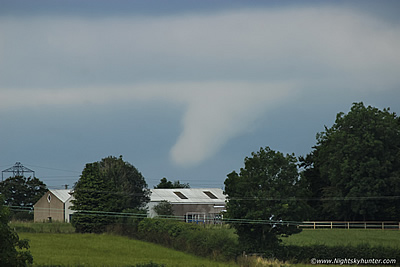 |
| On September 17th 2021 we were taken completely by surprise when the best aurora in four years suddenly manifested in the skies over the north coast when a weak slow moving CME combined with a Bz of -12 generated a sudden G2 geomagnetic storm. After filming the lights of Portrush by drone we relocated to the newly re-vamped Magheracross car park near Portrush where we watched the spectacle in a bright moonlit sky. We were shocked to observe twin and even triple tiers with green and red vertical beams +40 degrees high all easily visible with the naked eye, no one had expected an aurora of this caliber at all. One page report with 14 images and 2 video clips. - REPORT. | 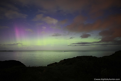 |
| On September 27th 2021 I was planning a random night shoot when suddenly I saw a post from Will Gater on twitter about an Atlas V rocket stage deburn at 22.10 BST visible from the UK. Not expecting to see much I decided to drive out under the dark skies of Beaghmore and set up my cameras and do a watch with low expectations. What I saw completely blew me away when both stages appeared as two bright naked eye comets with fanning tails casting shadows on the ground as they rapidly moved from the NE into the N like two ghostly apparitions in the sky. I managed to capture several images of this rare spectacle on camera making this an unforgettable experience. One page report with 8 images. - REPORT. | 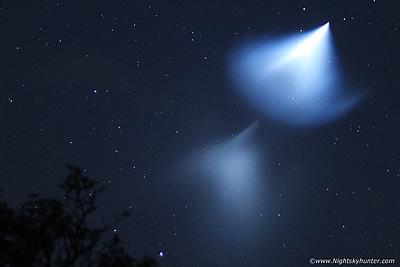 |
| C/2021 A1 Leonard was the brightest comet of the year. Even though the comet was no NEOWISE and never become an obvious sight for the public it still put on a nice show as seen through telescopes during December. This report documents a battle with inclement weather and the only three nights on which I observed this long period comet. On two occasions I spied it with the naked eye, in the scope it had a ghostly tail 1 & 1/4 degrees in length filled with streamers. The highlight was a night at Davagh Forest under pristine dark skies where I got my only image of Leonard using a star tracker mount thanks to the generosity of a mate. One page report with 4 images. - REPORT. | 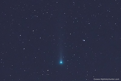 |
| Something a little different. Under cover of darkness on December 15th/16th 2021 I drove to Larne to film a famous wind turbine installation vessel called the MPI Adventure. The trip was a gamble, I arrived under stars & captured Port of Larne and the berthed MPI lit with lights. Then without warning the vessel left her berth and sailed out into the Irish Sea in perfect conditions with a tranquil ocean, calm winds, clear sky and golden hour light with the rising Winter sun. After seeking this vessel for two years I finally captured drone footage of her and had a great adventure doing so. One page report with 11 images and 2 video clips. - REPORT. | 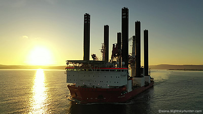 |
It's that time of year again when I release my end of year video presentation. This one is called Lucid, the reason is that catching a tornado on the ground in N. Ireland has been my dream, that dream happened this Summer however due to bad roads and trees I never got an image of the tornado on the ground or during its most striking phase, however I did get the funnel lifting. So my dream was only partly achieved, lucid is a dream state, hence the title. A combination of time lapse, ground and drone video and DSLR stills of astro phenomena, storm chases, thunderstorms, funnel clouds, comet Leonard, Winter magic, heatwave sunsets, Cumulonimbus cells, aurora, NLCs and more. Thanks very much for watching, I look forward to what wonders 2022 will bring. Martin McKenna.
Martin McKenna
